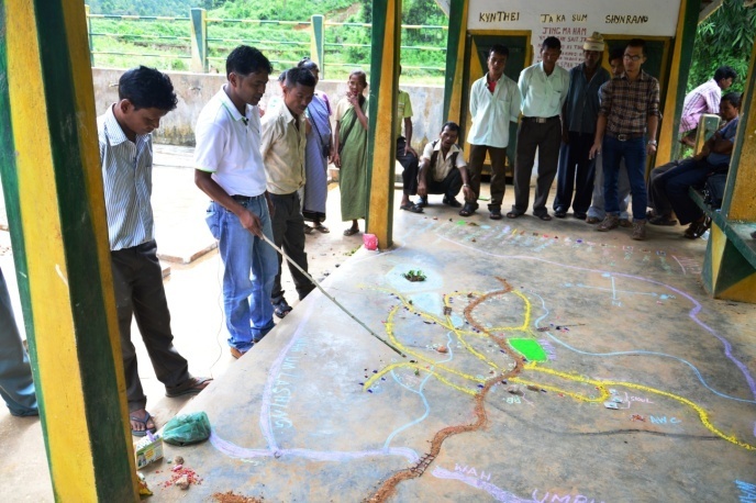
Under IBDLP, MINR has undertaken extensive mapping of the state of Meghalaya, primarily under the Integrated Village Development Plan (IVDP). The IVDP initiative is an attempt toward baseline documentation of villages throughout the state of Meghalaya. This documentation covers a number of areas that require intensive participation by village community members themselves: the village’s history, its social institutions and natural resources, calendar of seasonality, livelihood portfolios, inflow and outflow of commodities and services to/from the village, local-level changes in climate and the coping and adaptation strategy of the villagers, the vision and mission of the primary stakeholder of different age groups and gender, and the list of entrepreneur-farmers who are successfully marketing their products (or those who have attempted but failed). The goal is to share these village-level insights at the cluster, block, district, and state level in order to ensure uniformity of understanding by all governance stakeholders on how best to intervene, or how best to build the capacity of the village so that it can participate in plans for its sustainable development. About 450 villages have been covered under IVDP so far.
MAPPING A VILLAGE
Field experiences in the state have generally shown that villages do not maintain a map of village boundaries and are not fully aware of the geographical area of their village. Thus one of the initial exercises undertaken by the IVDP team is to locate the G.P.S. coordinates of all important landmarks in and around the village, and use the PRA exercise in the village to map the extreme North, South, East and West boundaries of the village as far as feasible. The GPS tracking itself has been done from the inception of the IVDP work, with the help of community volunteers themselves who are trained to handle GPS equipment and understand this mapping technique. Nearly 600 community volunteers have been mobilised under IVDP, and trained and deployed in GPS based data collection, data analysis and report writing.


OUTCOME OF MAPPING AND PLANNING
A key outcome of the IVDP exercise is that it facilitates community based natural resource management (NRM). For example, IVDP has resulted in deep social knowledge on village-level natural resource issues such as people’s recollection of the reduction in number of oranges or bees over a period of time, current shortages in drinking water or water for irrigation and possible reasons for the same, and so on.
This participatory exercise also catalyses careful thinking by community members around the natural resource problems and management solutions that may be critical for their village. Further, it allows the creation of a natural resource database with in-depth qualitative information in addition to quantitative data; both sources will be available on a single platform. This comprehensive natural resource database can then be used to create NRM and climate change adaptation plans at the local and at the state level.
FURTHER MAPPING UNDER MEGHA-LAMP
The IFAD assisted Meghalaya Livelihoods & Access to Markets Project (or ‘Megha-LAMP’) is the key statewide project under IBDLP launched in 2015. Different kinds of mapping initiatives contribute a core knowledge base for this project.
The key mapping activities under Megh-LAMP are outlined below:
- Maps for each village will be created using satellite data available from the North East Space Applications Centre or alternatively, via remote imagery from Unmanned Aerial Vehicles (UAV) operated by NECTAR (North East Centre for Technology and Applied Research).
- Information from the satellite / remote imagery mapping will be stored in GIS databases, with information about soil, drainage etc. being stored in different layers.
- GPS equipment will be used to map the centre of the target village, and key features such as houses with numbers assigned to each and other buildings, pathways, drinking water sources, springs, wells, streams, hills and land uses, such as agriculture, grazing area, forest, etc.
- Data from the satellite maps can also be used to identify potential locations for specific crop-based enterprises, and for development of water resources. Recording features such as extent of soil erosion, problem soils, distance from water sources, etc. can contribute toward identifying such locations.
In addition to project implementation team leading NRM activities under IBDLP, a full-time GIS unit has been established in MBDA for database and knowledge management related to these extensive mapping initiatives. Their role is to input the numerous kinds of information about each village as data layers into the master GIS database, facilitate database queries to produce insights about villages, natural resources, watersheds and overall regions of the state, and to work with the communications team within MBDA to share these insights with MBDA project team stakeholders, and with the communities themselves.
DISTRICT-WISE STATUS OF IMPLEMENTATION OF IVDP
Total Villages where IVDP is completed, as on August 2016 - 445
